|
|
|
|
Sat, 01 Aug, 2026
|

|

|
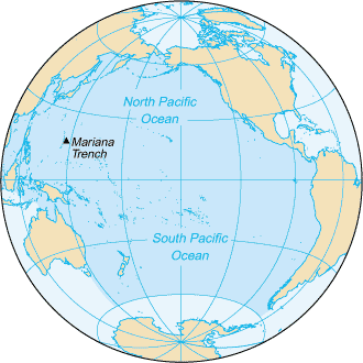
The Pacific Ocean (from the Latin name Mare Pacificum, "peaceful sea", bestowed upon it by the Portuguese explorer Ferdinand Magellan) is the world's largest body of water. It encompasses a third of the Earth's surface, having an area of 179.7 million square kilometres (69.4 million sq miles). Extending approximately 15,500 kilometres (9,600 miles) from the Bering Sea in the Arctic to the icy margins of Antarctica's Ross Sea in the south (although the Antarctic regions of the Pacific are sometimes described as part of the circumpolar Southern Ocean) the Pacific reaches its greatest east-west width at about 5°N latitude, where it stretches approximately 19,800 kilometres (12,300 miles) from Indonesia to the coast of Colombia. The western limit of the ocean is often placed at the Strait of Malacca. The lowest point on earth—the Mariana Trench—lies some 10,911 metres (35,797 ft) below sea level.The Pacific contains about 25,000 islands (more than the total number in the rest of the world's oceans combined), the majority of which are found south of the equator. (See: Pacific Islands.)Along the Pacific Ocean's irregular western margins lie many seas, the largest of which are the Celebes Sea, Coral Sea, East China Sea, Sea of Japan, South China Sea, Sulu Sea, Tasman Sea, and Yellow Sea. The Straits of Malacca joins the Pacific and the Indian Oceans on the west, and the Straits of Magellan links the Pacific with the Atlantic Ocean on the east.As the Pacific straddles the ±180° longitude where East becomes West, the Asian side of the ocean (where latitudes are E) is correctly referred to as East Pacific and the opposite side (eastwards) where latitudes are W is the West Pacific. To retain the popular "left is western" and "right is eastern" means of reference, the Western Pacific is thus the East Pacific and the Eastern Pacific the West Pacific. The International Date Line follows the ±180° longitude to the greater part of its North-South demarcation but veers far eastwards around Kiribati ( Caroline Island, which, not coincidentally, was renamed Millennium Island) and westwards round the Aleutian Islands as can be seen on the map at International Date Line.For most of Ferdinand Magellan's voyage from the Straits of Magellan to the Philippines, the Portuguese explorer indeed found the ocean peaceful. However, the Pacific is not always peaceful. Many typhoons and hurricanes batter the islands of the Pacific and the lands around the Pacific rim are full of volcanoes and often rocked by earthquakes. Tsunamis, caused by underwater earthquakes, have devastated many islands and wiped out whole towns.
 Jump to Page Contents Jump to Page Contents
|
|

Pay as you go
No monthly charges. Access for the price of a phone call
Go>
Unmetered
Flat rate dialup access from only £4.99 a month Go>
Broadband
Surf faster from just £13.99 a month Go> |
Save Even More
Combine your phone and internet, and save on your phone calls
More Info> |
This weeks hot offer
 24: Series 5
In association with Amazon.co.uk £26.97 |
|
Contents
Water characteristics
Geology
Landmasses
History and economy
Ports and harbours
Water characteristics - Contents
Water temperatures in the Pacific vary from freezing in the poleward areas to about 29° C (84° F) near the equator. Salinity also varies latitudinally. Water near the equator is less salty than that found in the mid-latitudes because of abundant equatorial precipitation throughout the year. Poleward of the temperate latitudes salinity is also low, because little evaporation of seawater takes place in these frigid areas.The surface circulation of Pacific waters is generally clockwise in the Northern Hemisphere (the North Pacific Gyre) and counter-clockwise in the Southern Hemisphere. The North Equatorial Current, driven westward along latitude 15°N by the trade winds, turns north near the Philippines to become the warm Japan or Kuroshio Current. Turning eastward at about 45°N, the Kuroshio forks and some waters move northward as the Aleutian Current, while the rest turn southward to rejoin the North Equatorial Current. The Aleutian Current branches as it approaches North America and forms the base of an counter-clockwise circulation in the Bering Sea. Its southern arm becomes the chilled slow, south-flowing California Current.The South Equatorial Current, flowing west along the equator, swings southward east of New Guinea, turns east at about 50°S, and joins the main westerly circulation of the Southern Pacific, which includes the Earth-circling Antarctic Circumpolar Current. As it approaches the Chilean coast, the South Equatorial Current divides; one branch flows around Cape Horn and the other turns north to form the Peru or Humboldt Current.
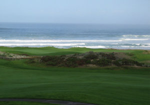 View of the Pacific Ocean from Pebble Beach.
Geology - Contents
The Andesite Line is the most significant regional distinction in the Pacific. It separates the deeper, basic igneous rock of the Central Pacific Basin from the partially submerged continental areas of acidic igneous rock on its margins. The Andesite Line follows the western edge of the islands off California and passes south of the Aleutian arc, along the eastern edge of the Kamchatka Peninsula, the Kuril Islands, Japan, the Mariana Islands, the Solomon Islands, and New Zealand. The dissimilarity continues northeastward along the western edge of the Albatross Cordillera along South America to Mexico, returning then to the islands off California. Indonesia, the Philippines, Japan, New Guinea, and New Zealand—all eastward extensions of the continental blocks of Australia and Asia—lie outside the Andesite Line.Within the closed loop of the Andesite Line are most of the deep troughs, submerged volcanic mountains, and oceanic volcanic islands that characterize the Central Pacific Basin. It is here that basaltic lavas gently flow out of rifts to build huge dome-shaped volcanic mountains whose eroded summits form island arcs, chains, and clusters. Outside the Andesite Line, volcanism is of the explosive type, and the Pacific Ring of Fire is the world's foremost belt of explosive volcanism.
Landmasses - Contents
The largest landmass entirely within the Pacific Ocean is the island of New Guinea— the second largest in the world. Almost all of the smaller islands of the Pacific lie between 30°N and 30°S, extending from South-east Asia to Easter Island; the rest of the Pacific Basin is almost entirely submerged.The great triangle of Polynesia, connecting Hawaii, Easter Island, and New Zealand, encompasses the island arcs and clusters of the Cook, Marquesas, Samoa, Society, Tokelau, Tonga, Tuamotu, Tuvalu and Wallis and Futuna islands.North of the equator and west of the international date line are the numerous small islands of Micronesia, including the Caroline Islands, the Marshall Islands, and the Mariana Islands.In the southwestern corner of the Pacific lie the islands of Melanesia, dominated by New Guinea. Other important island groups of Melanesia include the Bismarck Archipelago, Fiji, New Caledonia, the Solomon Islands, and Vanuatu.Islands in the Pacific Ocean are of four basic types: continental islands, high islands, coral reefs, and uplifted coral platforms. Continental islands lie outside the Andesite Line and include New Guinea, the islands of New Zealand, and the Philippines. These islands are structurally associated with the nearby continents. High islands are of volcanic origin, and many contain active volcanoes. Among these are Bougainville, Hawaii, and the Solomon Islands.The third and fourth types of islands are both the result of coralline island building. Coral reefs are low-lying structures that have built up on basaltic lava flows under the ocean's surface. One of the most dramatic is the Great Barrier Reef off northeastern Australia. A second island type formed of coral is the uplifted coral platform, which is usually slightly larger than the low coral islands. Examples include Banaba (formerly Ocean Island) and Makatea in the Tuamotu group of French Polynesia.
History and economy - Contents
See the Oceania article for information on one set of the Pacific Island states listed below here.Important human migrations occurred in the Pacific in prehistoric times, most notably those of Polynesians from the asian edge of the ocean to Tahiti and then to Hawaii and New Zealand. See Polynesian Voyaging Society.The ocean was sighted by Europeans early in the 16th century, first by Vasco Núñez de Balboa ( 1513) and then by Ferdinand Magellan, who crossed the Pacific during his circumnavigation ( 1519- 1522). In 1564 conquistadors crossed the ocean from Mexico led by Miguel López de Legazpi who sailed to the Philippines and Mariana Islands. For the remainder of the 16th century Spanish influence was paramount, with ships sailing from Spain to the Philippines, New Guinea, and the Solomons. The Manila Galleons linked Manila and Acapulco.During the 17th century the Dutch, sailing around southern Africa, dominated discovery and trade; Abel Janszoon Tasman discovered ( 1642) Tasmania and New Zealand. The 18th century marked a burst of exploration by the Russians in Alaska and the Aleutian Islands, the French in Polynesia, and the British in the three voyages of James Cook (to the South Pacific and Australia, Hawaii, and the North American Pacific Northwest).Growing imperialism during the 19th century resulted in the occupation of much of Oceania by Great Britain and France, followed by the United States. Significant contributions to oceanographic knowledge were made by the voyages of the HMS Beagle in the 1830s, with Charles Darwin aboard; the HMS Challenger during the 1870s; the USS Tuscarora (1873-76); and the German Gazelle ( 1874- 1876). Although the United States took the Philippines in 1898, Japan controlled the western Pacific by 1914, and occupied many other islands during World War II. By the end of that war the U.S. Pacific Fleet was the virtual master of the ocean.Seventeen independent states are located in the Pacific: Australia, Fiji, Japan, Kiribati, Marshall Islands, Micronesia, Nauru, New Zealand, Palau, Papua New Guinea, the Philippines, Samoa, Solomon Islands, Republic of China (Taiwan), Tonga, Tuvalu, and Vanuatu. Eleven of these nations have achieved full independence since 1960. The Northern Mariana Islands are self-governing with external affairs handled by the United States, and Cook Islands and Niue are in similar relationships with New Zealand. Also within the Pacific is the US state of Hawaii and several island territories and possessions of Australia, Chile, Ecuador, France, Japan, New Zealand, the United Kingdom, and the United States.The exploitation of the Pacific's mineral wealth is hampered by the ocean's great depths. In shallow waters of the continental shelves off the coasts of Australia and New Zealand, petroleum and natural gas are extracted, and pearls are harvested along the coasts of Australia, Japan, Papua New Guinea, Nicaragua, Panama, and the Philippines, although in sharply declining volume in some cases. The Pacific's greatest asset is its fish. The shoreline waters of the continents and the more temperate islands yield herring, salmon, sardines, snapper, swordfish, and tuna, as well as shellfish.In 1986, the member nations of the South Pacific Forum declared the area a nuclear-free zone in an effort to halt nuclear testing and prevent the dumping of nuclear waste there.
Ports and harbours - Contents
-
Acapulco (Mexico)
-
Anchorage ( United States)
-
Auckland (New Zealand)
-
Brisbane (Australia)
-
Buenaventura (Colombia)
-
Callao (Peru)
-
Guayaquil (Ecuador)
-
Hong Kong ( Hong Kong ( China (PRC)))
-
Honolulu ( United States)
-
Kobe (Japan)
-
Long Beach ( United States)
-
Los Angeles ( United States)
-
Panama City (Panama)
-
Portland (Oregon) ( United States)
-
Prince Rupert (Canada)
-
San Diego ( United States)
-
San Francisco ( United States)
-
Sapporo (Japan)
-
Seattle ( United States)
-
Shanghai ( China (PRC))
-
Sydney (Australia)
-
Taipei ( China (ROC))
-
Vancouver (Canada)
-
Victoria (Canada)
-
Vladivostok (Russia)
-
Yokohama (Japan).........
|
Change Text Size:
[A]
[default]
[A] |


 |
|
|
|
|