|
|
|
|
Sun, 26 Jul, 2026
|

|

|
République du Mali
Republic of Mali
 |
 |
|
Flag |
Coat of arms |
|
|
Motto: One people, one goal, one faith (French: Un peuple, un but, une foi) |
|
Anthem: Pour l'Afrique et pour toi, Mali |
 |
| Capital |
Bamako
12°39′ N 8°0′ W |
| Largest city |
Bamako |
| Official language(s) |
French |
| Government
President
Prime Minister
|
Parliamentary democracy
Amadou Toumani Touré
Ousmane Issoufi Maïga |
Independence
Declared |
From France
September 22, 1960 |
Area
• Total
• Water (%) |
1,240,000 km² ( 24th)
{{{areami²}}} mi²
1.6%% |
Population
• 2005 est.
• [[As of |]] census
• Density |
12,291,529 ( 67th)
9/km² ( 174th)
{{{population_densitymi²}}}/mi² |
GDP ( PPP)
• Total
• Per capita |
2004 estimate
,485,000,000 ( 129th)
,024 ( 176th) |
| HDI ( 2003) |
0.333 ( 174th) – low |
| Currency |
CFA franc ( XOF) |
Time zone
• Summer ( DST) |
( UTC0)
( UTC+1) |
| Internet TLD |
.ml |
| Calling code |
+223 |
|
|
The Republic of Mali (République du Mali) is a landlocked nation in West Africa. It is the second largest country among West African nations. It borders Algeria on the north, Niger on the east, Burkina Faso and the Côte d'Ivoire on the south, Guinea on the south-west, and Senegal and Mauritania on the west. Its straight borders on the north stretch into the centre of the Sahara desert, while the country's south, where the majority of inhabitants live, features the Niger and Senegal rivers. Formerly French Sudan, the country is named after the Empire of Mali.
 Jump to Page Contents Jump to Page Contents
|
|

Pay as you go
No monthly charges. Access for the price of a phone call
Go>
Unmetered
Flat rate dialup access from only £4.99 a month Go>
Broadband
Surf faster from just £13.99 a month Go> |
Save Even More
Combine your phone and internet, and save on your phone calls
More Info> |
This weeks hot offer
 24: Series 5
In association with Amazon.co.uk £26.97 |
|
Contents
History
Politics
Regions
Geography
Economy
Demographics
History - Contents
The Mandé peoples settled the Sahel (including present-day Mali), and formed a succession of Sahelian kingdoms, including the Ghana Empire, the Mali Empire, and the Songhai Empire. Timbuktu was a key city in these empires as an outpost for trans-Saharan trade and a center for scholarship. The Songhai Empire declined under a Moroccan invasion in 1591.Mali was invaded by France starting in 1880, which annexed it as an overseas department of France. The colony, which at times also included neighbouring countries, was known as French Sudan or the Sudanese Republic. In early 1959, the union of Mali and Senegal became the Mali Federation, which gained independence from France on June 20, 1960. Senegal withdrew from the Mali Federation after a few months. The Republic of Mali, under Modibo Keïta, withdrew from the French Community on September 22, 1960.Mali was ruled by a series of dictators from independence until 1991. Anti-government protests in 1991 led to a coup, a transitional government, and a new constitution. In 1992, Alpha Oumar Konaré won Mali's first democratic, multi-party presidential election. Upon his reelection in 1997, President Konaré pushed through political and economic reforms and fought corruption. In 2002 he was succeeded in democratic elections by Amadou Toumani Touré, a retired General, who had been the leader of the military aspect of 1991 democratic uprising.
Politics - Contents
Mali's constitution provides for a multi-party democracy, with the only restriction being a prohibition against parties based on ethnic, religious, regional, or gender lines. The National Assembly is the sole legislative arm of the government. It currently consists of 147 members. Representation is apportioned according to the population of administrative districts. The government has a 5 year term.
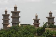
Regions - Contents
 Children of Buguni Mali
Mali is divided into nine regions, including the capital district of Bamako:
-
Bamako Capital District
-
Gao
-
Kayes
-
Kidal
-
Koulikoro
-
Mopti
-
Ségou
-
Sikasso
-
Tombouctou
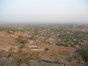
Geography - Contents
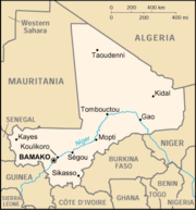 Map of Mali
Mali is landlocked and has a subtropical to arid climate. It is mostly flat, rising to rolling northern plains covered by sand, with savanna around the Niger River in the south. The hills of the Air Massif and Djado Plateau lie in the northeast. Most of the country lies in the Sahara Desert, which produces a hot, dust-laden harmattan haze common during dry seasons and leads to recurring droughts. The nation has considerable natural resources, with gold, uranium, phosphates, kaolin, salt and limestone being most widely exploited.See List of cities in Mali
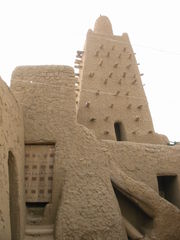
Economy - Contents
 market in Kati (Mali)
 New mosque in Mali
 Djenné au Mali
Mali is among the poorest countries in the world, with 65% of its land area desert or semidesert. Economic activity is largely confined to the riverine area irrigated by the Niger River. About 10% of the population is nomadic and some 80% of the labor force is engaged in farming and fishing. Industrial activity is concentrated on processing farm commodities. Mali is heavily dependent on foreign aid and vulnerable to fluctuations in world prices for cotton, its main export. In 1997, the government continued its successful implementation of an IMF-recommended structural adjustment program that is helping the economy grow, diversify, and attract foreign investment. Mali's adherence to economic reform, and the 50% devaluation of the African franc in January 1994, has pushed up economic growth. Several multinational corporations increased gold mining operations in 1996- 1998, and the government anticipates that Mali will become a major Sub-Saharan gold exporter in the next few years.
Demographics - Contents
Mali's population consists of diverse Sub-Saharan ethnic groups, sharing similar historic, cultural, and religious traditions. Exceptions are the Tuaregs and Maurs, desert nomads, related to the North African Berbers. The Tuaregs traditionally have opposed the central government. Starting in June 1990,in the North by Tuaregs seeking greater autonomy led to clashes with the military. In April 1992, the government and most opposing factions signed a pact to end the fighting and restore stability in the north. Its major aims are to allow greater autonomy to the north and increase government resource allocation to what has been a traditionally impoverished region. The peace agreement was celebrated in 1996 in Timbuktu during an official and highly publicized ceremony called "Flamme de la Paix"--(peace flame). |
Change Text Size:
[A]
[default]
[A] |


 |
|
|
|
|