 |
|
|
|
Sat, 25 Jul, 2026
|

|

|
Plate tectonics (from the Greek word for "one who constructs and destroys", τεκτων, tekton) is a theory of geology developed to explain the phenomenon of continental drift and is currently the theory accepted by the vast majority of scientists working in this area. In the theory of plate tectonics the outermost part of the Earth's interior is made up of two layers: the outer lithosphere and the inner asthenosphere.The lithosphere essentially "floats" on the asthenosphere and is broken-up into ten major plates: African, Antarctic, Australian, Eurasian, North American, South American, Pacific, Cocos, Nazca, and the Indian plates. These plates (and the more numerous minor plates) move in relation to one another at one of three types of plate boundaries: convergent (or destructive, two plates push against one another), divergent (or constructive, two plates move away from each other), and transform (two plates slide past one another). Earthquakes, volcanic activity, mountain-building, and oceanic trench formation occur along plate boundaries (most notably around the Pacific Ring of Fire).Plate tectonic theory arose out of two separate geological observations: continental drift, noticed in the early 20th century, and seafloor spreading, noticed in the 1960s. The theory itself was developed during the late 1960s and has since almost universally been accepted by scientists and has revolutionized the earth sciences (akin in its unifying and explanatory power for diverse geological phenomena as the development of the periodic table was for chemistry, the discovery of the genetic code for genetics, evolution in biology, and the theory of relativity in physics).
 The tectonic plates of the world were mapped in the second half of the 20th century.This image shows the direction in which the plates are moving. Click the image to see a larger version.
 Jump to Page Contents Jump to Page Contents
|
|

Pay as you go
No monthly charges. Access for the price of a phone call
Go>
Unmetered
Flat rate dialup access from only £4.99 a month Go>
Broadband
Surf faster from just £13.99 a month Go> |
Save Even More
Combine your phone and internet, and save on your phone calls
More Info> |
This weeks hot offer
 24: Series 5
In association with Amazon.co.uk £26.97 |
|
Contents
Key principles
Types of plate boundaries
Sources of plate motion
Major plates
History and impact
Plate tectonics on Other Planets
Metaphoric uses
Key principles - Contents
The division of the Earth's interior into lithospheric and asthenospheric components is based on their mechanical differences. The lithosphere is cooler and more rigid, whilst the asthenosphere is hotter and mechanically weaker. This division should not be confused with the chemical subdivision of the Earth into (from innermost to outermost) core, mantle, and crust. The key principle of plate tectonics is that the lithosphere exists as separate and distinct tectonic plates, which "float" on the fluid-like asthenosphere. The relative fluidity of the asthenosphere allows the tectonic plates to undergo motion in different directions.One plate meets another along a plate boundary, and plate boundaries are commonly associated with geological events such as earthquakes and the creation of topographic features like mountains, volcanoes and oceanic trenches. The majority of the world's active volcanoes occur along plate boundaries, with the Pacific Plate's Ring of Fire being most active and famous. These boundaries are discussed in further detail below.Tectonic plates are comprised of two types of lithosphere: continental and oceanic lithospheres; for example, the African Plate includes the continent and parts of the floor of the Atlantic and Indian Oceans. The distinction is based on the density of constituent materials; oceanic lithospheres are denser than continental ones due to their greater mafic mineral content. As a result, the oceanic lithospheres generally lie below sea level (for example the entire Pacific Plate, which carries no continent), while the continental ones project above sea level (see isostasy for explanation of this principle).
Types of plate boundaries - Contents
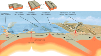 Three types of plate boundary.
There are three types of plate boundaries, characterised by the way the plates move relative to each other. They are associated with different types of surface phenomena. The different types of plate boundaries are:
- Transform boundaries occur where plates slide, or perhaps more accurately grind, past each other along transform faults. The relative motion of the two plates is either sinistral (left side toward the observer) or dextral (right side toward the observer).
- Divergent boundaries occur where two plates slide apart from each other.
- Convergent boundaries (or active margins) occur where two plates slide towards each other commonly forming either a subduction zone (if one plate moves underneath the other) or an orogenic belt (if the two simply collide and compress).
Plate boundary zones occur in more complex situations where three or more plates meet and exhibit a mixture of the above three boundary types.
Transform (conservative) boundaries
The left- or right-lateral motion of one plate against another along transform faults can cause highly visible surface effects. Because of friction, the plates cannot simply glide past each other. Rather, stress builds up in both plates and when it reaches a level that exceeds the slipping-point of rocks on either side of the transform-faults the accumulated potential energy is released as strain, or motion along the fault. The massive amounts of energy that are released are the cause of earthquakes, a common phenomenon along transform boundaries.A good example of this type of plate boundary is the San Andreas Fault complex, which is found in the western coast of North America and is one part of a highly complex system of faults in this area. At this location, the Pacific and North American plates move relative to each other such that the Pacific plate is moving north with respect to North America. In 50 million years or so, the part of California that is west of the San Andreas Fault will be a seperate island near the Alaska area.
Divergent (constructive) boundaries
At divergent boundaries, two plates move apart from each other and the space that this creates is filled with new crustal material sourced from molten magma that forms below. The origin of new divergent boundaries at triple junctions is sometimes thought to be associated with the phenomenon known as hotspots. Here, exceedingly large convective cells bring very large quantities of hot asthenospheric material near the surface and the kinetic energy is thought to be sufficient to break apart the lithosphere. The hot spot which may have initiated the Mid-Atlantic Ridge system currently underlies Iceland which is widening at a rate of a few centimetres per century.Divergent boundaries are typified in the oceanic lithosphere by the rifts of the oceanic ridge system, including the Mid-Atlantic Ridge, and in the continental lithosphere by rift valleys such as the famous East African Great Rift Valley. Divergent boundaries can create massive fault zones in the oceanic ridge system. Spreading is generally not uniform, so where spreading rates of adjacent ridge blocks are different massive transform faults occur. These are the fracture zones, many bearing names, that are a major source of submarine earthquakes. A sea floor map will show a rather strange pattern of blocky structures that are separated by linear features perpendicular to the ridge axis. If one views the sea floor between the fracture zones as conveyor belts carrying the ridge on each side of the rift away from the spreading center the action becomes clear. Crest depths of the old ridges, parallel to the current spreading center, will be older and deeper (due to thermal contraction and subsidence).It is at mid-ocean ridges that one of the key pieces of evidence forcing acceptance of the sea-floor spreading hypothesis was found. Airborne geomagnetic surveys showed a strange pattern of symmetrical magnetic reversals on opposite sides of ridge centres. The pattern was far too regular to be coincidental as the widths of the opposing bands were too closely matched. Scientists had been studying polar reversals and the link was made. The magnetic banding directly corresponds with the Earth's polar reversals. This was confirmed by measuring the ages of the rocks within each band. The banding furnishes a map in time and space of both spreading rate and polar reversals.
Convergent (destructive) boundaries
The nature of a convergent boundary depends on the type of lithosphere in the plates that are colliding. Where a dense oceanic plate collides with a less-dense continental plate, the oceanic plate is typically thrust underneath, forming a subduction zone. At the surface, tonly an oceanic trench on the ocean side and a mountain range on the continental side. An example of a continental-oceanic subduction zone is the area along the western coast of South America where the oceanic Nazca Plate is being subducted beneath the continental South American Plate. As the subducting plate descends, its temperature rises driving off volatiles (most importantly water). As this water rises into the mantle of the overriding plate, it lowers its melting temperature, resulting in the formation of magma with large amounts of dissolved gases. This can erupt to the surface, forming long chains of volcanoes inland from the continental shelf and parallel to it. The continental spine of South America is dense with this type of volcano. In North America the Cascade mountain range, extending north from California's Sierra Nevada, is also of this type. Such volcanoes are characterized by alternating periods of quiet and episodic eruptions that start with explosive gas expulsion with fine particles of glassy volcanic ash and spongy cinders, followed by a rebuilding phase with hot magma. The entire Pacific ocean boundary is surrounded by long stretches of volcanoes and is known collectively as The Ring of Fire.Where two continental plates collide the plates either crumple and compress or one plate burrows under or (potentially) overrides the other. Either action will create extensive mountain ranges. The most dramatic effect seen is where the northern margins of the Indian subcontinental plate is being thrust under a portion of the Eurasian plate, lifting it and creating the Himalaya.When two oceanic plates converge they form an island arc as one oceanic plate is subducted below the other. Good examples of this type of plate convergence would be Japan and the Aleutian Islands in Alaska.
|
|
|
|
Continental / Continental
|
|
Sources of plate motion - Contents
As noted above, the plates are able to move because of the relative weakness of the asthenosphere. Dissipation of heat from the mantle is acknowledged to be the source of energy driving plate tectonics. Somehow, this energy must be converted into force in order for the plates to move. There are essentially two forces that could be driving plate motion: friction and gravity. These are further subdivided below.
Friction
- Mantle drag
-
Convection currents in the mantle are transmitted through the asthenosphere; motion is driven by friction between the asthenosphere and the lithosphere.
- Trench suction
- Local convection currents exert a downward frictional pull on plates in subduction zones at ocean trenches.
Gravity
- Ridge-push
- Plate motion is driven by the higher elevation of plates at mid-ocean ridges. Essentially stuff slides downhill. The higher elevation is caused by the relatively low density of hot material upwelling in the mantle. The real motion producing force is the upwelling and the energy source that runs it. This is a misnomer as nothing is pushing and tensional features are dominant along ridges. Also, it is difficult to explain continental break-up with this.
- Slab-pull
- Plate motion is driven by the weight of cold, dense plates sinking into the mantle at trenches.
There is considerable evidence that convection is occurring in the mantle at some scale. The upwelling of material at mid-ocean ridges is almost certainly part of this convection. Some early models of plate tectonics envisioned the plates riding on top of convection cells like conveyor belts. However, most scientists working today believe that the asthenosphere is not strong enough to directly cause motion by friction. Slab pull is widely believed to be the strongest force directly operating on plates. Recent models indicate that trench suction plays an important role as well. The over-all driving force and its energy source are still debatable subjects of on-going research.
- Lunar drag
- In a study published in the January-February 2006 issue of the Geological Society of America's journal Bulletin, a team of Italian and U.S. scientists argue that the westward motion of the world's tectonic plates is due to the tidal attraction of the moon. As the Earth spins eastward beneath the moon, they say, the moon's gravity ever so slightly holds the Earth's surface layer back. This "lunar drag" causes the crust to slip slowly westward. [1]
Major plates - Contents
The main plates are
-
African Plate, covering Africa
-
Antarctic Plate, covering Antarctica
-
Australian Plate, covering Australia (fused with Indian Plate between 50 and 55 million years ago)
-
Eurasian Plate covering Eurasia
-
North American Plate covering North America and north-east Siberia
-
South American Plate covering South America
-
Pacific Plate, covering the Pacific Ocean
Notable minor plates include the Indian Plate and the Arabian Plate.The movement of plates has caused the formation and breakup of continents over time, including occasional formation of a supercontinent that contains most or all of the continents. The supercontinent Rodinia is thought to have formed about 1000 million years ago and to have embodied most or all of Earth's continents, and broken up into eight continents around 600 million years ago. The eight continents later re-assembled into another supercontinent called Pangaea; Pangea eventually broke up into Laurasia (which became North America and Eurasia) and Gondwana (which became the remaining continents).
- Related article
History and impact - Contents
Continental drift
Continental drift was one of many ideas about tectonics proposed in the late 19th and early 20th centuries. The theory has been superseded by and the concepts and data have been incorporated within plate tectonics.By 1915 Alfred Wegener was making serious arguments for the idea with the first edition of The Origin of Continents and Oceans. In that book he noted how the east coast of South America and the west coast of Africa looked as if they were once attached. Wegener wasn't the first to note this ( Francis Bacon, Benjamin Franklin and Snider-Pellegrini preceded him), but he was the first to marshal significant fossil and paleo-topographical and climatological evidence to support this simple observation. However, his ideas were not taken seriously by many geologists, who pointed out that there was no apparent mechanism for continental drift. Specifically they did not see how continental rock could plow through the much denser rock that makes up oceanic crust.In the early 1940s, Maurice Ewing seismically tested the Atlantic edge of the North American continental shelf, and found a granitic layer dropped down to the basaltic ocean floor. If the continent had been torn from Europe and was plowing through the ocean bottom, the edge of the continental shelf should have marked the end of granitic rocks. Later studies aboard the Atlantis found that ocean bottom was not smooth, which suggested it was much stronger than if continents could push it aside.Beginning in the 1950s, scientists, using magnetic instruments ( magnetometers) adapted from airborne devices developed during World War II to detect submarines, began recognizing odd magnetic variations across the ocean floor. This finding, though unexpected, was not entirely surprising because it was known that basalt -- the iron-rich, volcanic rock making up the ocean floor-- contains a strongly magnetic mineral ( magnetite) and can locally distort compass readings. This distortion was recognized by Icelandic mariners as early as the late 18th century. More important, because the presence of magnetite gives the basalt measurable magnetic properties, these newly discovered magnetic variations provided another means to study the deep ocean floor. When newly formed rock cools, such magnetic materials recorded the Earth's magnetic field at the time.As more and more of the seafloor was mapped during the 1950s, the magnetic variations turned out not to be random or isolated occurrences, but instead revealed recognizable patterns. When these magnetic patterns were mapped over a wide region, the ocean floor showed a zebra-like pattern. Alternating stripes of magnetically different rock were laid out in rows on either side of the mid-ocean ridge: one stripe with normal polarity and the adjoining stripe with reversed polarity. The overall pattern, defined by these alternating bands of normally and reversely polarized rock, became known as magnetic striping.When the rock strata of the tips of separate continents are very similar it suggests that these rocks were formed in the same way implying that they were joined initially. For instance, some parts of Scotland contain rocks very similar to those found in eastern North America. Furthermore, the Caledonian Mountains of Europe and parts of the Appalachian Mountains of North America are very similar in structure and lithology.
Floating continents
The prevailing concept was that there were static shells of strata under the continents. It was early observed that although granite existed on continents, seafloor seemed to be composed of denser basalt. It was apparent that a layer of basalt underlies continental rocks.However, based upon abnormalities in plumb line deflection by the Andes in Peru, Pierre Bouguer deduced that less-dense mountains must have a downward projection into the denser layer underneath. The concept that mountains had "roots" was confirmed by George B. Airy a hundred years later during study of Himalayan gravitation, and seismic studies detected corresponding density variations.By the mid-1950s the question remained unresolved of whether mountain roots were clenched in surrounding basalt or were floating like an iceberg.
Plate tectonic theory
Significant progress was made in the 1960s, and was prompted by a number of discoveries, most notably the Mid-Atlantic ridge. The most notable was the 1962 publication of a paper by American geologist Harry Hess ( Robert S. Dietz published the same idea one year earlier in Nature. However, priority belongs to Hess, since he distributed an unpublished manuscript of his 1962 article already in 1960). Hess suggested that instead of continents moving through oceanic crust (as was suggested by continental drift) that an ocean basin and its adjoining continent moved together on the same crustal unit, or plate. In the same year, Robert R. Coats of the U.S. Geological Survey described the main features of island arc subduction in the Aleutian Islands. His paper, though little-noted (and even ridiculed) at the time, has since been called "seminal" and "prescient". In 1967, Jason Morgan proposed that the Earth's surface consists of 12 rigid plates that move relative to each other. Two months later, in 1968, Xavier Le Pichon published a complete model based on 6 major plates with their relative motions.Explanation of magnetic striping
 Seafloor magnetic striping.
The discovery of magnetic striping and the stripes being symmetrical around the crests of the mid-ocean ridges suggested a relationship. In 1961, scientists began to theorise that mid-ocean ridges mark structurally weak zones where the ocean floor was being ripped in two lengthwise along the ridge crest. New magma from deep within the Earth rises easily through these weak zones and eventually erupts along the crest of the ridges to create new oceanic crust. This process, later called seafloor spreading, operating over many millions of years has built the 50,000 km-long system of mid-ocean ridges. This hypothesis was supported by several lines of evidence:
- at or near the crest of the ridge, the rocks are very young, and they become progressively older away from the ridge crest;
- the youngest rocks at the ridge crest always have present-day (normal) polarity;
- stripes of rock parallel to the ridge crest alternated in magnetic polarity (normal-reversed-normal, etc.), suggesting that the Earth's magnetic field has flip-flopped many times.
By explaining both the zebralike magnetic striping and the construction of the mid-ocean ridge system, the seafloor spreading hypothesis quickly gained converts and represented another major advance in the development of the plate-tectonics theory. Furthermore, the oceanic crust now came to be appreciated as a natural "tape recording" of the history of the reversals in the Earth's magnetic field.Subduction discovered
A profound consequence of seafloor spreading is that new crust was, and is now, being continually created along the oceanic ridges. This idea found great favor with some scientists who claimed that the shifting of the continents can be simply explained by a large increase in size of the Earth since its formation. However, this so-called "expanding Earth" hypothesis was unsatisfactory because its supporters could offer no convincing geologic mechanism to produce such a huge, sudden expansion. Most geologists believe that the Earth has changed little, if at all, in size since its formation 4.6 billion years ago, raising a key question: how can new crust be continuously added along the oceanic ridges without increasing the size of the Earth?This question particularly intrigued Harry Hess, a Princeton University geologist and a Naval Reserve Rear Admiral, and Robert S. Dietz, a scientist with the U.S. Coast and Geodetic Survey who first coined the term seafloor spreading. Dietz and Hess were among the small handful who really understood the broad implications of sea floor spreading. If the Earth's crust was expanding along the oceanic ridges, Hess reasoned, it must be shrinking elsewhere. He suggested that new oceanic crust continuously spread away from the ridges in a conveyor belt-like motion. Many millions of years later, the oceanic crust eventually descends into the oceanic trenches -- very deep, narrow canyons along the rim of the Pacific Ocean basin. According to Hess, the Atlantic Ocean was expanding while the Pacific Ocean was shrinking. As old oceanic crust was consumed in the trenches, new magma rose and erupted along the spreading ridges to form new crust. In effect, the ocean basins were perpetually being "recycled," with the creation of new crust and the destruction of old oceanic lithosphere occurring simultaneously. Thus, Hess' ideas neatly explained why the Earth does not get bigger with sea floor spreading, why there is so little sediment accumulation on the ocean floor, and why oceanic rocks are much younger than continental rocks.Mapping with earthquakes
During the 20th century, improvements in seismic instrumentation and greater use of earthquake-recording instruments ( seismographs) worldwide enabled scientists to learn that earthquakes tend to be concentrated in certain areas, most notably along the oceanic trenches and spreading ridges. By the late 1920s, seismologists were beginning to identify several prominent earthquake zones parallel to the trenches that typically were inclined 40-60° from the horizontal and extended several hundred kilometers into the Earth. These zones later became known as Wadati-Benioff zones, or simply Benioff zones, in honor of the seismologists who first recognized them, Kiyoo Wadati of Japan and Hugo Benioff of the United States. The study of global seismicity greatly advanced in the 1960s with the establishment of the Worldwide Standardized Seismograph Network (WWSSN) to monitor the compliance of the 1963 treaty banning above-ground testing of nuclear weapons. The much-improved data from the WWSSN instruments allowed seismologists to map precisely the zones of earthquake concentration worldwide.
Geological paradigm shift
The acceptance of the theories of continental drift and sea floor spreading (the two key elements of plate tectonics) can be compared to the Copernican revolution in astronomy (see Nicolaus Copernicus). Within a matter of only several years geophysics and geology in particular were revolutionized. The parallel is striking: just as pre-Copernican astronomy was highly descriptive but still unable to provide explanations for the motions of celestial objects, pre-tectonic plate geological theories described what was observed but struggled to provide any fundamental mechanisms. The problem lay in the question "How?". Before acceptance of plate tectonics, geology in particular was trapped in a "pre-Copernican" box.However, by comparison to astronomy the geological revolution was much more sudden. What had been rejected for decades by any respectable scientific journal was eagerly accepted within a few short years in the 1960s and 1970s. Any geological description before this had been highly descriptive. All the rocks were described and assorted reasons, sometimes in excruciating detail, were given for why they were where they are. The descriptions are still valid. The reasons, however, today sound much like pre-Copernican astronomy.One simply has to read the pre-plate descriptions of why the Alps or Himalaya exist to see the difference. In an attempt to answer "how" questions like "How can rocks that are clearly marine in origin exist thousands of meters above sea-level in the Dolomites?", or "How did the convex and concave margins of the Alpine chain form?", any true insight was hidden by complexity that boiled down to technical jargon without much fundamental insight as to the underlying mechanics.With plate tectonics answers quickly fell into place or a path to the answer became clear. Collisions of converging plates had the force to lift sea floor into thin atmospheres. The cause of marine trenches oddly placed just off island arcs or continents and their associated volcanoes became clear when the processes of subduction at converging plates were understood.Mysteries were no longer mysteries. Forests of complex and obtuse answers were swept away. Why were there striking parallels in the geology of parts of Africa and South America? Why did Africa and South America look strangely like two pieces that should fit to anyone having done a jigsaw puzzle? Look at some pre-tectonics explanations for complexity. For simplicity and one that explained a great deal more look at plate tectonics. A great rift, similar to the Great Rift Valley in northeastern Africa, had split apart a single continent, eventually forming the Atlantic Ocean, and the forces were still at work in the Mid-Atlantic Ridge.We have inherited some of the old terminology, but the underlying concept is as radical and simple as "The Earth moves" was in astronomy.
Plate tectonics on Other Planets - Contents
As a result of 1999 observations of the magnetic fields on Mars by the Mars Global Surveyor spacecraft, it has been proposed that the mechanisms of plate tectonics may once have been active on the planet - see Geology of Mars.
Otherwise considered to be a "twin" of the Earth, Venus shows no evidence of plate tectonics - see Geology of Venus.
Metaphoric uses - Contents
Sometimes the idea moving tectonic plates is used metaphorically, e.g. "the tectonic plates have moved" in a BBC TV news program describing the political effects of Ariel Sharon's illness on 4 January 2005. |
Change Text Size:
[A]
[default]
[A] |


 |
|
|
|
|


