 |
|
|
|
Sat, 01 Aug, 2026
|

|

|
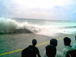 The tsunami that struck Malé in the Maldives on December 26, 2004.
A tsunami ( IPA pronunciation /suˈnɑːmi/ or /tsuˈnɑːmi/]) is a series of waves generated when water in a lake or the sea is rapidly displaced on a massive scale. Earthquakes, landslides, volcanic eruptions and large meteorite impacts all have the potential to generate a tsunami. The effects of a tsunami can range from unnoticeable to devastating.The term tsunami comes from the Japanese language meaning harbour ("tsu", 津) and wave ("nami", 波 or 浪). Although in Japanese tsunami is used for both the singular and plural, in English tsunamis is well-established as the plural. The term was created by fishermen who returned to port to find the area surrounding the harbour devastated, although they had not been aware of any wave in the open water. A tsunami is not a sub-surface event in the deep ocean; it simply has a much smaller amplitude (wave heights) offshore, and a very long wavelength (often hundreds of kilometres long), which is why they generally pass unnoticed at sea, forming only a passing "hump" in the ocean.Tsunamis have been historically referred to as tidal waves because as they approach land they take on the characteristics of a violent onrushing tide rather than the sort of cresting waves that are formed by wind action upon the ocean (with which people are more familiar). However, since they are not actually related to tides the term is considered misleading and its usage is discouraged by oceanographers.
 Jump to Page Contents Jump to Page Contents
|
|

Pay as you go
No monthly charges. Access for the price of a phone call
Go>
Unmetered
Flat rate dialup access from only £4.99 a month Go>
Broadband
Surf faster from just £13.99 a month Go> |
Save Even More
Combine your phone and internet, and save on your phone calls
More Info> |
This weeks hot offer
 24: Series 5
In association with Amazon.co.uk £26.97 |
|
Contents
Causes
Characteristics
Tsunami wave
Signs of an approaching tsunami
Warnings and prevention
Past tsunamis
Causes - Contents
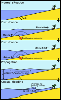 Schema of a tsunami
A tsunami can be generated by any disturbance that rapidly moves a large mass of water, such as an earthquake, volcanic eruption, landslide or meteorite impact. However, the most common cause is an undersea earthquake. An earthquake which is too small to create a tsunami by itself may trigger an undersea landslide quite capable of generating a tsunami.Tsunamis can be generated when the sea floor abruptly deforms and vertically displaces the overlying water. Such large vertical movements of the earth's crust can occur at plate boundaries. Subduction earthquakes are particularly effective in generating tsunamis, and occur where denser oceanic plates slip under continental plates in a process known as subduction.Sub-marine landslides; which are sometimes triggered by large earthquakes; as well as collapses of volcanic edifices, may also disturb the overlying water column as sediment and rocks slide downslope and are redistributed across the sea floor. Similarly, a violent submarine volcanic eruption can uplift the water column and form a tsunami.Waves are formed as the displaced water mass moves under the influence of gravity to regain its equilibrium and radiates across the ocean like ripples on a pond.In the 1950s it was discovered that larger tsunamis than previously believed possible could be caused by landslides, explosive volcanic action and impact events. These phenomena rapidly displace large volumes of water, as energy from falling debris or expansion is transferred to the water into which the debris falls. Tsunamis caused by these mechanisms, unlike the ocean-wide tsunamis caused by some earthquakes, generally dissipate quickly and rarely affect coastlines distant from the source due to the small area of sea affected. These events can give rise to much larger local shock waves ( solitons), such as the landslide at the head of Lituya Bay which produced a water wave estimated at 50 – 150 m and reached 524 m up local mountains. However, an extremely large landslide could generate a megatsunami that might have ocean-wide impacts.
Characteristics - Contents
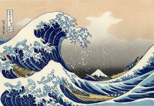 There is a common misconception that tsunamis behave like wind-driven waves or swells (with air behind them, as in this celebrated 19th century woodcut by Hokusai). In fact, a tsunami is better understood as a new and suddenly higher sea level, which manifests as a shelf or shelves of water. The leading edge of a tsunami superficially resembles a breaking wave but behaves differently: the rapid rise in sea level, combined with the weight and pressure of the ocean behind it, has far greater force.
Although often referred to as "tidal waves", a tsunami does not look like the popular impression of "a normal wave only much bigger". Instead it looks rather like an endlessly onrushing tide which forces its way around and through any obstacle. Most of the damage is caused by the huge mass of water behind the initial wave front, as the height of the sea keeps rising fast and floods powerfully into the coastal area. The sheer weight of water is enough to pulverise objects in its path, often reducing buildings to their foundations and scouring exposed ground to the bedrock. Large objects such as ships and boulders can be carried several miles inland before the tsunami subsides.Tsunamis act very differently from typical surf swells; they are phenomena which move the entire depth of the ocean (often several kilometres deep) rather than just the surface, so they contain immense energy, propagate at high speeds and can travel great trans-oceanic distances with little overall energy loss. A tsunami can cause damage thousands of kilometres from its origin, so there may be several hours between its creation and its impact on a coast, arriving long after the seismic wave generated by the originating event arrives. Although the total or overall loss of energy is small, the total energy is spread over a larger and larger circumference as the wave travels, so the energy per linear meter in the wave decreases as the inverse power of the distance from the source. This is the two-dimensional equivalent of the inverse square law in three dimensions.A single tsunami event may involve a series of waves of varying heights; the set of waves is called a train. In open water, tsunamis have extremely long periods (the time for the next wave top to pass a point after the previous one), from minutes to hours, and long wavelengths of up to several hundred kilometres. This is very different from typical wind-generated swells on the ocean, which might have a period of about 10 seconds and a wavelength of 150 metres.The actual height of a tsunami wave in open water is often less than one metre. This is often practically unnoticeable to people on ships. The energy of a tsunami passes through the entire water column to the sea bed, unlike surface waves, which typically reach only down to a depth of 10 m or so.The wave travels across the ocean at speeds from 500 to 1,000 km/h. As the wave approaches land, the sea shallows and the wave no longer travels as quickly, so it begins to 'pile-up'; the wave-front becomes steeper and taller, and there is less distance between crests. While a person at the surface of deep water would probably not even notice the tsunami, the wave can increase to a height of 30 m or more as it approaches the coastline and compresses. The steepening process is analogous to the cracking of a tapered whip. As a wave goes down the whip from handle to tip, the same energy is deposited in less and less material, which then moves more violently as it receives this energy.A wave becomes a 'shallow-water wave' when the ratio between the water depth and its wavelength gets very small, and since a tsunami has an extremely large wavelength (hundreds of kilometres), tsunamis act as a shallow-water wave even in deep oceanic water. Shallow-water waves move at a speed that is equal to the square root of the product of the acceleration of gravity (9.8 m/s2) and the water depth. For example, in the Pacific Ocean, where the typical water depth is about 4000 m, a tsunami travels at about 200 m/s (720 km/h or 450 mi/h) with little energy loss, even over long distances. At a water depth of 40 m, the speed would be 20 m/s (about 72 km/h or 45 mi/h), which is much slower than the speed in the open ocean but the wave would still be difficult to outrun. However a conjecture exists for velocities. The passing "hump" mentioned earlier is a "momentum flux" equal to density multiplied by the square of the velocity. This gives the transient pressure built up during the quake as equal to twice and in addition to the hydrostatic pressure. There is no proof for this.Tsunamis propagate outward from their source, so coasts in the "shadow" of affected land masses are usually fairly safe. However, tsunami waves can diffract around land masses (as shown in this Indian Ocean tsunami animation as the waves reach southern Sri Lanka and India). They also need not be symmetrical; tsunami waves may be much stronger in one direction than another, depending on the nature of the source and the surrounding geography.Local geographic peculiarities can lead to seiche or standing waves forming, which can amplify the onshore damage. For instance, the tsunami that hit Hawaii on April 1, 1946 had a fifteen-minute interval between wave fronts. The natural resonant period of Hilo Bay is about thirty minutes. That meant that every second wave was in phase with the motion of Hilo Bay, creating a seiche in the bay. As a result, Hilo suffered worse damage than any other place in Hawaii, with the tsunami/seiche reaching a height of 14 m and killing 159 inhabitants.
Tsunami wave - Contents
Ocean waves are normally divided into three groups, characterized by depth:
- Deep water
- Intermediate water
- Shallow water
Even though a tsunami is generated in deep water (around 4000m below mean sea level), tsunami waves are considered shallow-water waves. As the tsunami wave approaches the shallow waters of shore, its time period remains the same, but its wavelength decreases rapidly, thus causing the water to pile up to form tremendous crests, in an effect known as "shoaling".Tsunamis form " solitary waves", or waves with crests but no troughs — more like sand dunes than sine waves. Tsunami waves are also called "N-waves", as they resemble the English letter "N".
Signs of an approaching tsunami - Contents
The following have at various times been associated with a tsunami [1]:
- An earthquake may be felt.
- Large quantities of gas may bubble to the water surface and make the sea look as if it is boiling.
- The water in the waves may be unusually hot.
- The water may smell of rotten eggs ( Hydrogen sulfide) or of petrol or oil.
- The water may sting the skin.
- A thunderous boom may be heard followed by
- a roaring noise as of a jet plane
- or a noise akin to the periodic whop-whop of a helicopter,
- or a whistling sound.
- The sea may recede to a considerable distance.
- A flash of red light might be seen near the horizon.
- As the wave approaches, the top of the wave may glow red.
Warnings and prevention - Contents
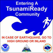 "TsunamiReady" sign in Ocean Shores in Grays Harbor, Washington
|
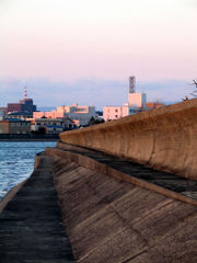 Tsunami wall at Tsu-shi, Japan
|
Tsunamis cannot be prevented or precisely predicted, but there are some warning signs of an impending tsunami, and there are many systems being developed and in use to reduce the damage from tsunamis.In instances where the leading edge of the tsunami wave is its trough, the sea will recede from the coast half of the wave's period before the wave's arrival. If the slope is shallow, this recession can exceed many hundreds of metres. People unaware of the danger may remain at the shore due to curiosity, or for collecting fish from the exposed sea bed.
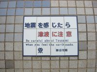 Tsunami warning sign on seawall in Kamakura, Japan, 2004. In the Muromachi period, a tsunami struck Kamakura, destroying the wooden building that housed the colossal statue of Amida Buddha at Kotokuin. Since that time, the statue has been outdoors.
In instances where the leading edge of the tsunami is its first peak, succeeding waves can lead to further flooding. Again, being educated about a tsunami is important, to realise that when the water level drops the first time, the danger is not yet over. In a low-lying coastal area, a strong earthquake is a major warning sign that a tsunami may be produced.Regions with a high risk of tsunamis may use tsunami warning systems to detect tsunamis and warn the general population before the wave reaches land. In some communities on the west coast of the United States, which is prone to Pacific Ocean tsunamis, warning signs advise people where to run in the event of an incoming tsunami. Computer models can roughly predict tsunami arrival and impact based on information about the event that triggered it and the shape of the seafloor ( bathymetry) and coastal land ( topography). [2]One of the early warnings comes from nearby animals. Many animals sense danger and flee to higher ground before the water arrives. The Lisbon quake is the first documented case of such a phenomenon in Europe. The phenomenon was also noted in Sri Lanka in the 2004 Indian Ocean earthquake ( [3]). Some scientists speculate that animals may have an ability to sense subsonic Rayleigh waves from an earthquake minutes or hours before a tsunami strikes shore (Kenneally, [4]).While it is not possible to prevent a tsunami, in some particularly tsunami-prone countries some measures have been taken to reduce the damage caused on shore. Japan has implemented an extensive programme of building tsunami walls of up to 4.5m (13.5 ft) high in front of populated coastal areas. Other localities have built floodgates and channels to redirect the water from incoming tsunamis. However, their effectiveness has been questioned, as tsunamis are often higher than the barriers. For instance, the tsunami which hit the island of Hokkaido on July 12, 1993 created waves as much as 30m (100 ft) tall - as high as a 10-story building. The port town of Aonae was completely surrounded by a tsunami wall, but the waves washed right over the wall and destroyed all the wood-framed structures in the area. The wall may have succeeded in slowing down and moderating the height of the tsunami but it did not prevent major destruction and loss of life.The effects of a tsunami can be mitigated by natural factors such as tree cover on the shoreline. Some locations in the path of the 2004 Indian Ocean tsunami escaped almost unscathed as a result of the tsunami's energy being sapped by a belt of trees such as coconut palms and mangroves. In one striking example, the village of Naluvedapathy in India's Tamil Nadu region suffered minimal damage and few deaths as the wave broke up on a forest of 80,244 trees planted along the shoreline in 2002 in a bid to enter the Guinness Book of Records. [5] Environmentalists have suggested tree planting along stretches of sea coast which are prone to tsunami risks. While it would take some years for the trees to grow to a useful size, such plantations could offer a much cheaper and longer-lasting means of tsunami mitigation than the costly and environmentally destructive method of erecting artificial barriers.
Past tsunamis - Contents
Tsunamis occur most frequently in the Pacific Ocean, but are a global phenomenon; they are possible wherever large bodies of water are found, including inland lakes, where they can be caused by landslides. Very small tsunamis, non-destructive and undetectable without specialized equipment, occur frequently as a result of minor earthquakes and other events.
6100 B.C. and before
In the North Atlantic Ocean ( Norwegian Sea), the Storegga Slides were a major series of sudden underwater land movements over the course of tens of thousands of years, which caused tsunamis and megatsunamis across a wide area.
1607 - Bristol Channel, England and Wales
In 2002 it was suggested that the Bristol Channel floods of 1607 in England and Wales, UK, may have been caused by a tsunami.
1700 - Vancouver Island, Canada
January 26 - The Cascadia Earthquake, one of the largest earthquakes on record, ruptures the Cascadia Subduction Zone offshore from Vancouver Island to northern California, creating a tsunami logged in Japan and oral traditions of the native americans.
1755 - Lisbon, Portugal
Tens of thousands of Portuguese who survived the great 1755 Lisbon earthquake were killed by a tsunami which followed a half hour later. Many townspeople fled to the waterfront, believing the area safe from fires and from falling debris from aftershocks. Before the great wall of water hit the harbour, waters retreated, revealing lost cargo and forgotten shipwrecks.The earthquake, tsunami, and subsequent fires killed more than a third of Lisbon's pre-quake population of 275,000. Historical records of explorations by Vasco da Gama and other early navigators were lost, and countless buildings were destroyed (including most examples of Portugal's Manueline architecture). Europeans of the 18th century struggled to understand the disaster within religious and rational belief systems. Philosophers of the Enlightenment, notably Voltaire, wrote about the event. The philosophical concept of the sublime, as described by philosopher Immanuel Kant in the Observations on the Feeling of the Beautiful and Sublime, took inspiration in part from attempts to comprehend the enormity of the Lisbon quake and tsunami.
1883 - Krakatoa explosive eruption
The island volcano of Krakatoa in Indonesia exploded with devastating fury in 1883, blowing its underground magma chamber partly empty so that much overlying land and seabed collapsed into it. A series of large tsunami waves was generated from the explosion, some reaching a height of over 40 metres above sea level. Tsunami waves were observed throughout the Indian Ocean, the Pacific Ocean, the American West Coast, South America, and even as far away as the English Channel. On the facing coasts of Java and Sumatra the sea flood went many miles inland and caused such vast loss of life that one area was never resettled but went back to the jungle and is now the Ujung Kulon nature reserve.
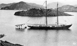 The aftermath of the tsunami that struck Newfoundland in 1929.
1929 - Newfoundland tsunami
On November 18, 1929, an earthquake of magnitude 7.2 occurred beneath the Laurentian Slope on the Grand Banks. The quake was felt throughout the Atlantic Provinces of Canada and as far west as Ottawa, Ontario and as far south as Claymont, Delaware. The resulting tsunami measured over 7 metres in height and took about 2½ hours to reach the Burin Peninsula on the south coast of Newfoundland, where 28 people lost their lives in various communities.
1946 - Pacific tsunami
The Aleutian Island earthquake tsunami that killed 165 people on Hawaii and Alaska resulted in the creation of a tsunami warning system, established in 1949 for Pacific Ocean area countries. The tsunami is locally known in Hawaii as the April Fools Day Tsunami in Hawaii due to people thinking the warnings were an April Fools prank.Note: The Pacific Tsunami Warning Center was established to track these killer waves and provide warning.
1960 - Chilean tsunami
The Great Chilean Earthquake, at magnitude 9.5 the strongest earthquake ever recorded. Its epicenter off the coast of South Central Chile, generated one of the most destructive tsunamis of the 20th century.It spread across the entire Pacific Ocean, with waves measuring up to 25 metres high. The first tsunami arrived at Hilo, Hawaii approximately 14.8 hrs after it originated off the coast of South Central Chile.The highest wave at Hilo Bay was measured at around 10.7m (35 ft.). 61 lives were lost allegedly due to people's failure to heed warning sirens. When the tsunami hit Onagawa, Japan, almost 22 hours after the quake, the wave height was 3 m above high tide. The number of people killed by the earthquake and subsequent tsunami is estimated to be between 490 and 2,290.
1963 - Vajont Dam disaster
The reservoir behind the Vajont Dam in northern Italy was struck by an enormous landslide. A tsunami was triggered which swept over the top of the dam (without bursting it) and into the valley below. Nearly 2,000 people were killed.
1964 - Good Friday tsunami
After the magnitude 9.2 Good Friday Earthquake, tsunamis struck Alaska, British Columbia, California and coastal Pacific Northwest towns, killing 121 people. The tsunamis were up to 6 m tall, and killed 11 people as far away as Crescent City, California.
1979 - Tumaco tsunami
A magnitude 7.9 earthquake occurred on December 12, 1979 at 7:59:4.3 ( UTC) along the Pacific coast of Colombia and Ecuador. The earthquake and the resulting tsunami caused the destruction of at least six fishing villages and the death of hundreds of people in the Colombian province of Nariño. The earthquake was felt in Bogotá, Cali, Popayán, Buenaventura and several other cities and towns in Colombia and in Guayaquil, Esmeraldas, Quito and other parts of Ecuador. When the Tumaco Tsunami hit the coast, it caused great destruction in the city of Tumaco, as well as in the small towns of El Charco, San Juan, Mosquera and Salahonda on the Pacific Coast of Colombia. The total number of victims of this tragedy was 259 dead, 798 wounded and 95 missing presumed dead.
1993 – Okushiri tsunami
A devastating tsunami occurred off the coast of Hokkaido in Japan as a result of an earthquake on July 12, 1993. As a result, 202 people on the small island of Okushiri lost their lives, and hundreds more were missing or injured.
2004 - Indian Ocean tsunami
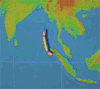 Animation of the 2004 Indonesian Tsunami from NOAA/PMEL Tsunami Research Program
The 2004 Indian Ocean earthquake, which had a magnitude of 9.15, triggered a series of lethal tsunamis on December 26, 2004 that killed approximately 275,000 people (more than 168,000 in Indonesia alone), making it the deadliest tsunami in recorded history. The tsunami killed people over an area ranging from the immediate vicinity of the quake in Indonesia, Thailand and the north-western coast of Malaysia to thousands of kilometres away in Bangladesh, India, Sri Lanka, the Maldives, and even as far as Somalia, Kenya and Tanzania in eastern Africa. The disaster prompted a huge worldwide effort to help victims of the tragedy, with billions of dollars being raised for disaster relief.
 Rescue operation on Marina Beach, Chennai in India on Dec.26,2004
Unlike in the Pacific Ocean, there is no organized alert service covering the Indian Ocean. This is in part due to the absence of major tsunami events between 1883 (the Krakatoa eruption, which killed 36,000 people) and 2004. In light of the 2004 Indian Ocean tsunami, UNESCO and other world bodies have called for a global tsunami monitoring system.
Other tsunamis in South Asia
Tsunamis in South Asia
(Source: Amateur Seismic Centre, India) [6] |
| Date |
Location |
|
1524 |
Near Dabhol, Maharashtra |
|
02 April 1762 |
Arakan Coast, Myanmar |
|
16 June 1819 |
Rann of Kachchh, Gujarat |
|
31 October 1847 |
Great Nicobar Island |
|
31 December 1881 |
Car Nicobar Island |
|
26 August 1883 |
Krakatoa volcanic eruption |
|
28 November 1945 |
Mekran coast, Balochistan |
|
26 December 2004 |
Banda Aceh, Indonesia; Tamil Nadu, Kerala, Andhra Pradesh, Andaman and Nicobar Islands, India; Sri Lanka; Thailand; Malaysia; Maldives; Somalia; Kenya; Tanzania |
Other historical tsunamis
Other tsunamis that have occurred include the following:
- circa 500 C.E.: Poompuhar, Tamil Nadu, India, Maldives
- 1541, Brazil. It happened in the first european settlement in Brazil, São Vicente. There is no record of deaths or injuries, but the town was almost completely destroyed.
- January 20, 1606/1607: along the coast of the Bristol Channel (main article) thousands of people were drowned, houses and villages swept away, farmland was inundated and flocks were destroyed by a flood that might have been a tsunami. The cause of the flood remains disputed, it is quite possible that it was caused by a combination of meteorological extremes and tidal peaks (discussion).
- January 26, 1700: the Cascadia Earthquake (estimated 9.0 magnitude) caused massive tsunamis across the Pacific Northwest
- One of the worst tsunami disasters engulfed whole villages along Sanriku, Japan, in 1896. A wave more than seven stories tall (about 20 m) drowned some 26,000 people.
- 1946: An earthquake in the Aleutian Islands sent a tsunami to Hawaii, killing 159 people (five died in Alaska).
-
July 9, 1958: A huge landslip caused the highest ever reported tsunami which was 524 metres high. This happened in the fjord shaped Lituya Bay, Alaska, USA. It travelled at over 150 kph.
- 1976: On 16 August (midnight) a tsunami killed more than 5000 people in the Moro Gulf region ( Cotabato City) of the Philippines.
-
May 26, 1983: 104 people in western Japan were killed by a tsunami spawned from a nearby earthquake.
-
17 July, 1998: A Papua New Guinea tsunami killed approximately 2200 people [7]. A 7.1 magnitude earthquake 24 km offshore was followed within 11 minutes by a tsunami about 12 m tall. While the magnitude of the quake was not large enough to create these waves directly, it is believed the earthquake generated an undersea landslide, which in turn caused the tsunami. The villages of Arop and Warapu were destroyed.
North American and Caribbean tsunamis
-
14 November 1840 - Great Swell on the Delaware River
-
18 November 1867 - Virgin Islands
-
17 November 1872 - Maine
-
11 October 1918 - Puerto Rico
-
18 November 1929 - Newfoundland
-
9 January 1926 - Maine
-
4 August 1946 - Dominican Republic
-
18 August 1946 - Dominican Republic
Possible Tsunamis
- 35 Million years ago - Chesapeake Bay impact crater, Chesapeake Bay
-
9 June 1913 - Longport, NJ
-
6 August 1923 - Rockaway Park, Queens, NY .
-
8 August 1924 - Coney Island, NY .
-
19 August 1931 - Atlantic City, NJ
-
21 September 1938 - Hurricane, NJ coast.
-
19 May 1964 - Northeast USA
-
4 July 1992 - Daytona Beach, FL
Source: NOAA National Weather Service Forecast Office
European tsunamis
-
16 October 1979 23 people died when the coast of Nice, France, was hit by a tsunami.
|
Change Text Size:
[A]
[default]
[A] |


 |
|
|
|
|